
DONATIONS NEEDED

UPDATE…JUNE 11, 2013…2:30 P.M. EDT
The Storm Prediction Center has indicated a MODERATE risk of Severe Thunderstorms OVER PARTS OF THE NRN PLNS/MID MO VLY…
…THERE IS A SLGT RISK OF SVR TSTMS FROM THE N CNTRL HIGH PLNS E INTO THE MID MS VLY…
SPC DAY 1 CONVECTIVE OUTLOOK

Based on analysis of forecast soundings information through F5 Data Severe Weather Software, indications are that the most likely chance for tornadic activity should be within the red outline of the following map. Isolated strong tornadoes may most likely be encountered within the pink hatched areas.

SPC CONVECTIVE WATCHES MAP

SPC CURRENT MESOSCALE DISCUSSIONS MAP

NWS HAZARDS AND WARNINGS

NWS DOPPLER RADAR

Good day everyone!
The Tropical Atlantic is fairly quiet this morning.
TROPICAL ATLANTIC SATELLITE LOOP IMAGERY

Three Tropical waves were noted on the 06Z NHC Surface Analysis Map.
NHC SURFACE ANALYSIS MAP

The wave located near 43-45W has just shown a flareup of convection. This wave is currently located where wind shear has been relaxing over the past 24-36 hours, and the GFS 06Z Zonal Shear map indicates upper level winds at the moment are more conducive for development than destructive. Albeit, I am not expecting development of this wave, as wind shear is forecast to increase within the next 24 hours, I will continue to monitor the wave, as it could possibly be a catalyst for possible development in the BOC region in a few days.
Also noted in the satellite loop imagery is an area of showers and thunderstorms near 10W, which has some slight cyclonic turning.
CATL SATELLITE LOOP IMAGERY

Analysis this morning of Global Computer Models indicates the GFS still being consistent with cyclogenesis, showing a weak system in about 9 days (216 hours) , and another system in 14 days. The ECMWF is showing agreement with the GFS on a system in the BOC at the same time frame, 216 hours.
GFS

ECMWF

The current wind shear product from CIMSS indicates wind shear is running about 30 knots over the GOMEX right now. The current zonal wind shear forecast from the GFS indicates the wind shear pattern to relax over the Yucatan Peninsula at 180 hours from 06Z, with a developing upper level anticyclone. The CMC is in fair agreement with this, and placing the forecast map in motion, the upper level anticyclone seems to be trending toward the BOC at that time.
CIMSS WIND SHEAR

GFS ZONAL WIND SHEAR 180 HOURS

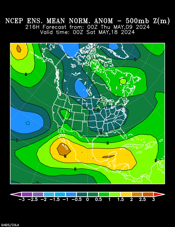
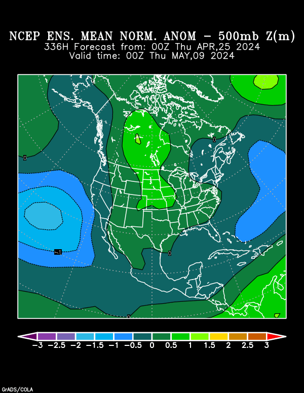
The NCEP Ensemble Mean Anomaly Departure map indicates lowering pressures over Central America at that time, at both 216 hours, and at 336 hours over the Yucatan Peninsula and BOC area. This has been consistent now for the past 72 hours.
NCEP ENSEMBLE 500 MB
NCEP ENSEMBLE BASED TROPICAL CYCLONE GENESIS PROBABILITY (120-240 HOURS) MULTI MODEL

NCEP ENSEMBLE

Based on these factors, I cannot rule out the formation of a tropical system per the model solutions, albeit most likely Tropical Depression status, unless the upper pattern changes.
I will continue to monitor this for any significant change to model solutions.
Elsewhere, Tropical Storm formation is not expected during the next 72-96 hours.
Have a blessed day!
T. F. “STORM” WALSH III
GMCS, USCG (ret)
METEOROLOGIST / HURRICANE SPECIALIST
MEMBER WEST CENTRAL FL AMS
CERTIFIED SKYWARN OFFICIAL STORM SPOTTER (advanced)
CoCoRaHS OBSERVER


In your best estimate, do you foresee a tropical storm or greater in the Orlando-Tampa area over the next 3 weeks? Planning a trip but last year plans were ruined thanks to TS Deby! I know weather can change at any time! Thanks!
Ann, right now it’s hard to say…don’t have anything that goes out that far in forecast time. The only model we have that does go out far in time is the GFS, which goes out to 384 hours which is 16 days. I could probably answer that better for you 10-14 days before your trip.
Thanks Storm. I want to send something out to you, is that address correct if I click on the CONTACT button at the top of the page? I know you moved a few months ago. I want to make sure it is right.
Yes sir…I just updated it.
Thanks, Storm. It looks like June is going to be busy. My understanding is that the Gulf States should maybe be a little more alert this year than recent years, both due to conditions off of Africa and conditions in the Caribbean. Is this accurate?
Yes ma’am.
That doesn’t make me happy, but i’d rather know than not know and I appreciate your expertise and willingness to share it with the rest of us. The Northshore house is almost done, but even in its present state, all we have to do is a generator test to be ready to use it as an extended family evacuation site. It is north of I-12 in Western St. Tammany Parish, so it is generally outside the mandtory evacuation zone.