
SEVERE WEATHER THREAT: MODERATE
TROPICAL STORM FORMATION: NONE
ALL forecasts contained on this site, are based on my analysis and knowledge of various forecast tools, including information contained in NHC products, and are not copies from any other entity.
*NOTE: In the TROPICAL STORM FORMATION line above, probabilities are for during the next 5 day period. My personal probability will be listed as either NONE, MONITORING or PROBABLE. This does not necessarily mean something will develop, but that certain forecast conditions are likely to be present, favoring development. Once NHC products become available, then the appropriate probability and percentage will be used.
Please refer to the link for the Storm Prediction Center in the box at the top of the page, just below the Hurricane Hunter graphics.
For those who have donated to my site, your help has been greatly appreciated. For those not aware, donations to my site help me offset my personal out of pocket expenses…such as some of the model maps you view on here, are only available due to my subscription to the corresponding site. The F5 Data maps I post, also another out of pocket expense (monthly subscription). Updates to software (weather related), and costs for my domain name are also out of pocket to me. Any help you provide is immensely appreciated!

Current Storm Total for 2015:
TOTAL STORMS: 2
HURRICANES: 0
INTENSE HURRICANES: 0
U.S. LANDFALLS: 2
StormW Seasonal Forecast:
TOTAL STORMS: 8 – 10
HURRICANES: 3 – 5
INTENSE HURRICANES: 1 – 2
Good day everyone!
Once again relatively quiet in the tropics. As I mentioned on one of the weather groups I am in on Facebook, there were two areas that kind of caught my eye yesterday in satellite imagery. The first, being a Tropical Wave which is located near 45W, and the second, an area of limited cloudiness over the Yucatan Peninsula. Analysis of satellite loop images this morning reveal the wave in question, and showers to the east of the wave, are associated with the ITCZ. Satellite presentation is not as well defined as it was yesterday, and based on surrounding dry air and current wind shear, as well as the recent forecast wind shear maps, does not indicate any threat of development with this are in the CATL.
CATL SATELLITE LOOP IMAGERY (CLICK TO ACTIVATE THE LOOP)

WATL SATELLITE LOOP IMAGERY

Satellite presentation of the area over the Yucatan Peninsula shows that cloudiness and convection has diminished greatly over the past 24 hours. Albeit there appears to be a slight cyclonic twist to a portion of the middle and lower cloud decks, this area is associated with somewhat of a diffuse surface trof just to the west, and an upper level low centered just off the NE tip of the Peninsula. Based on analysis of the current vorticity maps, there is no hint of vorticity near the surface, up through the mid levels of the atmosphere, and upper level winds are forecast to remain unfavorable for development over the area.
Elsewhere, global models do not indicate any development over the next 7-10 days.
The forecast of possible upward motion of the MJO has been pushed back, and is forecast to be in phases 6 and 7, which would tend to favor development in the western and central Pacific. We will have to see if the forecast for the MJO indicates any motion into Octants 8 and 1 within the following week of the forecast projection.
ECMWF MJO PHASE DIAGRAM FORECAST

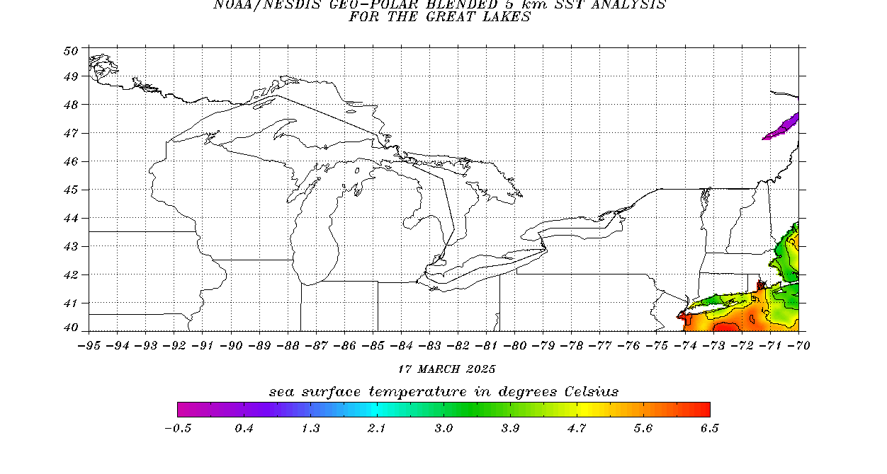
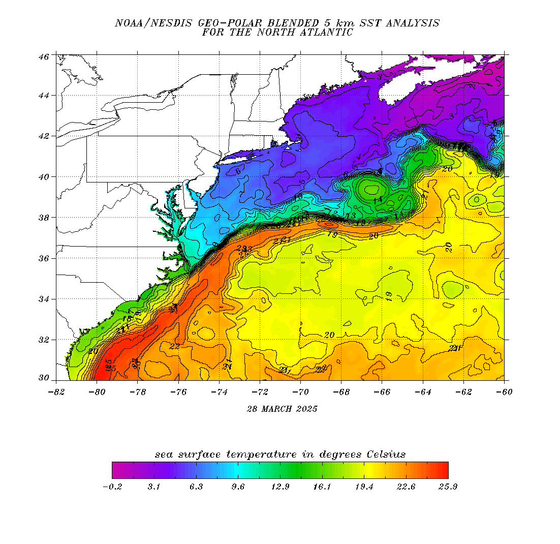
Again, my concern if the warmer SST’s remain in place over the GOMEX, and from the Bahamas northward along and off the U.S. east coast, is either close in development, in which we have already experienced 2. My concern is if something should make it from the Caribbean, or begin to develop north of the MDR, traversing into the Bahamas…later into the season.
GOMEX SST CHART
NORTH ATLANTIC SST CHART
UNISYS SST ANOMALY CHART
Have a blessed day!
T. F. “STORM” WALSH III
GMCS, USCG (ret)
METEOROLOGIST / HURRICANE SPECIALIST / SEVERE WEATHER SPECIALIST MEMBER WEST CENTRAL FLORIDA AMS
CoCoRAHS OBSERVER


Thank you everyone, for the Fathers day wishes. Same to all Father’s here!
Happy Father’s Day my friend!! Hope you have a great day!!
First, Happy Fathers Day, Storm. Second, I only received 0.65″ of rain from Bill’s remnants, up here. They were predicting 1-3″ in the Greater NYC Metro area. So Bill, “Busted” up here, for the most parts, but some area did get heavier rains Especially in Va. , De., Pa., and Southern NJ.
Happy Father’s Day Storm!
Thanks storm