
Good day everyone!
The Storm Prediction Center (SPC) has indicated a SLIGHT risk of Severe Thunderstorms FROM PARTS OF ERN SD AND WRN MN INTO THE MID-MO VALLEY AND CNTRL PLAINS…
…THERE IS A SLGT RISK OF SVR TSTMS OVER PORTIONS OF NRN FL…
SPC DAY 1 CONVECTIVE OUTLOOK

TORNADO PROBABILITY

Analysis of 12Z soundings from around the area indicated a fairly stable environment. However, based on information in the outlook, and analysis of the NCEP SREF model, and F5 Data Severe Weather Software (Utilizing the RAP and NAM-WRF output), steep lapse rates and increasing boundary layer moisture are forecast this afternoon over the risk area. Taken from the day 1 outlook:
IN THE WAKE OF THE INITIAL STORMS….STEEP LAPSE RATES AND INCREASING BOUNDARY LAYER MOISTURE CONTENT WILL YIELD A MODERATELY TO STRONGLY UNSTABLE WARM SECTOR BY AFTERNOON WITH MLCAPE VALUES APPROACHING 2000-3000+ J/KG. LATEST MODEL GUIDANCE SUGGESTS AN INCREASED LIKELIHOOD FOR SURFACE-BASED STORM DEVELOPMENT BY MID AFTERNOON FROM THE VICINITY OF THE NWRN KS LEE LOW NEWD ALONG THE COLD FRONT INTO CNTRL NEB WHERE STRONG HEATING WILL BOOST SFC TEMPERATURES IN THE 90S TO LOW 100S. GIVEN FAIRLY LARGE T-TD SPREADS AND MODEST /30-35 KT/ DEEP-LAYER SHEAR…HIGH-BASED MULTICELLS CAPABLE OF DAMAGING WINDS AND HAIL APPEAR PROBABLE.
Severe Weather software, and SREF Model out put indicate SBCAPE approaching 3000-4000 j/kg, and MLCAPE of 2000-3000 j/kg. Craven-Brooks Severe Signature values over a portion of the area are forecast to attain values of 50,000-65,000. These conditions are expected late this afternoon into early evening…approximately 4:00-7:00 p.m. EDT
Based on these parameters, I have outlined the area of greatest probability for tornadic activity in red. The most likely area to experience an isolated strong tornado, should tornadic activity occur, are within the pink hatched circles.

The following products are linked so you may retrieve updated information by clicking on them.
SPC CONVECTIVE WATCHES

SPC MESOSCALE DISCUSSIONS

NWS HAZARD AND WARNING MAP

NWS DOPPLER RADAR LOOP

TROPICAL WEATHER OUTLOOK / STATUS OF THE TROPICS
The Tropical Atlantic is still pretty quiet today. The NHC 06Z Surface Analysis map did indicate a Tropical Wave near 70W this morning. This may be the trigger for the system the GFS had been forecasting in the BOC in a few days.
TROPICAL ATLANTIC SATELLITE LOOP

WATL SATELLITE LOOP

The GFS has picked back up on development in the BOC, around the 19th of the month. Currently, the GFS is the only model supporting this…however in the early stages, the GFS was the only model consistently showing development when Andrea formed.
I cannot rule this out at this time as analysis of NCEP Ensemble products, forecast steering, and forecast wind shear pretty much are in support of what the GFS is currently showing.
Current wind shear is running on the order of 20-30 knots over the area and into the Caribbean Sea. However, the current GFS shear forecast indicates upper level winds may become conducive for development in about 5-6 days, with a well established upper level anticyclone over the BOC. The Zonal Shear indicates a fairly favorable pattern.
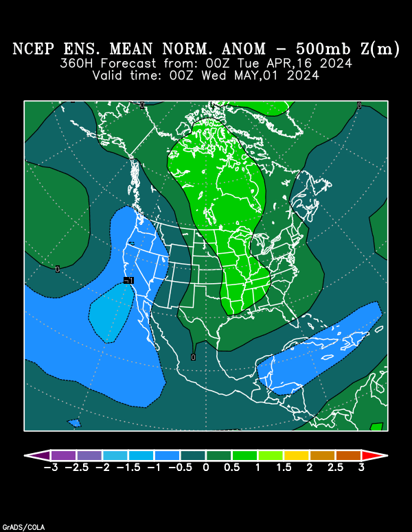
Along with this, the NCEP Ensemble 500 mb anomaly departure map still shows the lowering of pressures over the area from 144 hours in the forecast period, through 192 hours.
NCEP 500 MB ANOMALY DEPARTURE
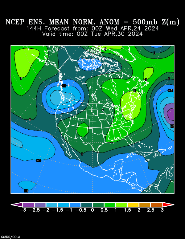

A significant lowering of pressures is forecast toward the end of the month as well
NCEP TROPICAL CYCLONE GENESIS (120-240 HOURS)

GFS ZONAL SHEAR FORECAST

CURRENT MJO FORECAST

I will continue to monitor this over the next several days.
Elsewhere, Tropical Storm formation is not expected through the next 72-96 hours.
For those wondering, here is a little bit on the state of the tropics:
The current wind shear pattern has been running pretty much close to climatology, especially in the Atlantic Basin
TROPICAL ATLANTIC VERTICAL SHEAR

Another item favoring a busier season is, vertical instability in the Tropical Atlantis is pretty much running at, or near climatology. This is a change from the last 2 seasons, where vertical instability was lacking, and running well below climatology
VERTICAL INSTABILITY

Another feature is SST Anomalies. The following are current anomalies
SST ANOMALIES FOR JUNE 13, 2013
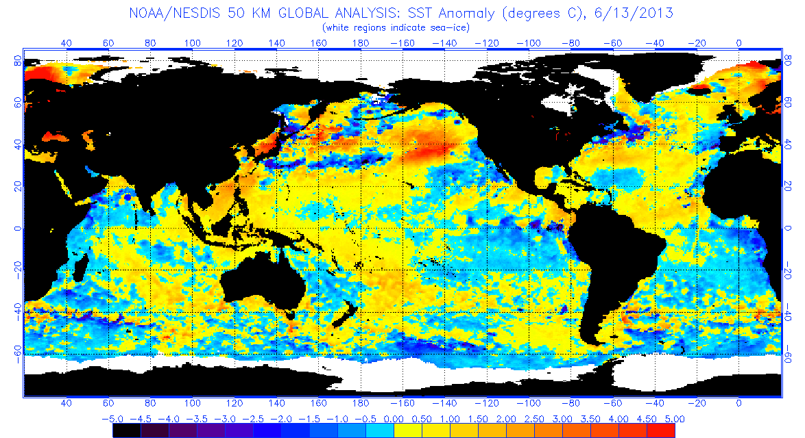
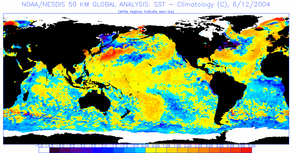
The best analog I could find, was from 2004. If you’ll note, the differences are very small, and the SST Anomaly pattern is almost identical
SST ANOMALIES FOR JUNE 12, 2004
Have a blessed day!
T. F. “STORM” WALSH III
GMCS, USCG (ret)
METEOROLOGIST / HURRICANE SPECIALIST
MEMBER WEST CENTRAL FL AMS
CERTIFIED SKYWARN OFFICIAL STORM SPOTTER (advanced)
CoCoRaHS OBSERVER


Surprise Invest in the extreme western Caribbean–93L., About 14.o N and 82.5W
Thanks Mr storm. We are. Bless to. Have. You.
Thank you, Greg!
As I was reading the synopsis I was wondering when the Wind shear might relax in the tropics and there was my answer at the bottem!! I appreciate all you do and hope to send you a donation in the very near future. You know how small them retirement checks are. But business is picking up!!!!
Get some rest you will need it its going to be a long season and all it takes is one in your neighbor hood to make it a bad one!!!!
Thanks Mike!
Prayers are with them.
Thank You Sir!!
Welcome, Monty!