
Disclaimer: This site is not affiliated with the National Hurricane Center, Hurricane Hunters, Storm Prediction Center, or National Weather Service. ALL forecasts herein are the result of my analysis, (to which you will see me at times, insert excerpts from various agencies due to the nature of the importance of the information) and I am solely responsible for the content. As ALWAYS, follow the National Hurricane Center, National Weather Service, and your local Emergency Management officials for emergency decisions. In addition, this is strictly a FORECAST OFFICE. I CANNOT make decisions regarding travel plans, etc. My purpose, is to provide you the information, based solely on information I analyze, and the accuracy of the information at hand of the time of analysis, so you may make informed decisions.
(T. F. “Storm” Walsh)
For those who have donated to my site, your help has been greatly appreciated. If you are not aware, donations to my site help pay for subscriptions to sites I use as well as software updates, which provide all the models and information used in my forecasts. To donate, please click the DONATE button to the right side of the page, or on the graphic of the dog. Any help you provide is immensely appreciated!
DONATIONS ACCEPTED AND APPRECIATED


Good day everyone!
I will be out of the office from 27 June through 29 June. I will resume updates upon my return.
Please note! In regard to the severe weather forecasts, I will try to have them back for ENHANCED areas or above, once some of the models I use for analysis come back up. They are still down, and contain information I use to provide a more accurate forecast.
Please use the following links regarding severe weather activity:
SPC HOMEPAGE LINK
https://www.spc.noaa.gov/classic.html
NADOCAST
http://data.nadocast.com/
I will reiterate, my forecasts are based on the available information at the time of analysis, and are only as accurate as the information analyzed and the solutions provided.
For those who follow me on Facebook, I must ask that you please bookmark this wordpress site, or visit my site on Facebook. https://www.facebook.com/groups/950628219042775
Due to the amount of weather groups I belong to, and emails I have to send out, I am not able to post to everyone personally. In posting personally, it takes about 1 hour to get my information out to everybody. Thanks for your understanding.
The following is my outlook forecast for the 2024 Atlantic Hurricane Season:
STORM W’s SEASONAL FORECAST
TOTAL NAMED STORMS: 23 – 26
TOTAL HURRICANES : 12 – 15
MAJOR HURRICANES: 6 – 8
AVERAGE HURRICANE SEASON:
TOTAL NAMED STORMS: 14
TOTAL HURRICANES: 7
MAJOR HURRICANES: 3
SEASON TOTALS
NAMED STORMS: 1
HURRICANES: 0
MAJOR HURRICANES: 0
The following are the storm names for the 2024 hurricane season. As each storm is named, they will be colored in red in order to keep track of the used names in the list:
| Alberto | Helene | Oscar |
| Beryl | Isaac | Patty |
| Chris | Joyce | Rafael |
| Debby | Kirk | Sara |
| Ernesto | Leslie | Tony |
| Francine | Milton | Valerie |
| Gordon | Nadine | William |
For those who have followed my over the years, you know as a system approaches the islands, or the U.S. coast, the updates tend to become longer. However the information is critical, and includes links to the NHC watch and warning areas with information regarding hazards affecting land such as wind, storm surge, rainfall, surf, tornadoes, and specific areas along with any changes to the advisory hazards. I also post storm surge maps from SLOSH data software, forecast rainfall, watch and warnings maps, etc. I will also post in general as part of the forecast, animated model maps of the system, current steering layer, etc. In the meantime, I did a little change, and have posted very good hurricane preparedness links to the site. Please click the following link to access this information.
https://stormw.wordpress.com/stormws-toolbox/
Analysis of satellite loop imagery indicates a few tropical waves within the ITCZ. There is a fairly healthy wave approaching the Lesser Antilles. Currently, analysis of shear, upper level, and moisture conditions appear favorable at the moment. The African satellite loop indicates the African wave train from earlier this morning.
GOES 16 IR LOOP

TROPICAL WAVE TRAIN

The following is from cyclonicwx.com
METEOSAT 10 AFRICAN LOOP

Regarding the wave approaching the Lesser Antilles, although conditions are favorable at the moment, global models are indicating conditions to become a little less favorable during the next 24 – 36 hours. At the moment, I do not believe this will develop prior to and crossing over the Lesser Antilles. I will continue to monitor this, as the ECMWF EPS Cyclone Formation Probability model indicates a 65 – 70% probability for a depression to form.

Regardless, this wave should bring some rain to the islands as it passes.
ECMWF AND GFS 72 HOUR RAINFALL FORECAST


Elsewhere, analysis this morning was anything less than aggravating. In my years of forecasting, I have never seen such disagreement among modeling regarding the MJO. I say aggravating, in that with such disagreement, it is not always easy to dispatch an accurate forecast. I did state that we should be loosing the MJO signal near months end. It does appear to be somewhat in the forecast. However, based on analysis of the current Ensemble Prediction System from the JMA and various MJO phase space diagrams, there is a major discrepancy in the forecast. The JMA Ensemble currently indicates PHASE 1 of the MJO, which would make sense seeing the tropical activity we just had. This is supposed to last until JUN 29.
Thereafter, the JMA Ensemble indicates PHASE 2 of the MJO for the second week, 29 JUN – 05 JUL. The ECMWF EPS also indicates PHASE 1 at the moment. However, after the 29th, it indicates the MJO going to PHASE 3 for the second week, and then PHASE 2 for the week of 04 JUL – 09 JUL.
By the same token, ALL the phase space diagram forecasts maintain the MJO in phases 3 and 4. In fact, the phase space diagrams, (with the exception of the ACCESS -S2) did not indicate PHASE 1 while we had the recent tropical activity. So, I will be monitoring the ITCZ for the next couple of weeks to see if anything may have the possibility of a development threat. I will mention however (and bear in mind this is 10 days out from today, so accuracy is questionable), some ensemble members indicate an increase in activity during the next 10 days.
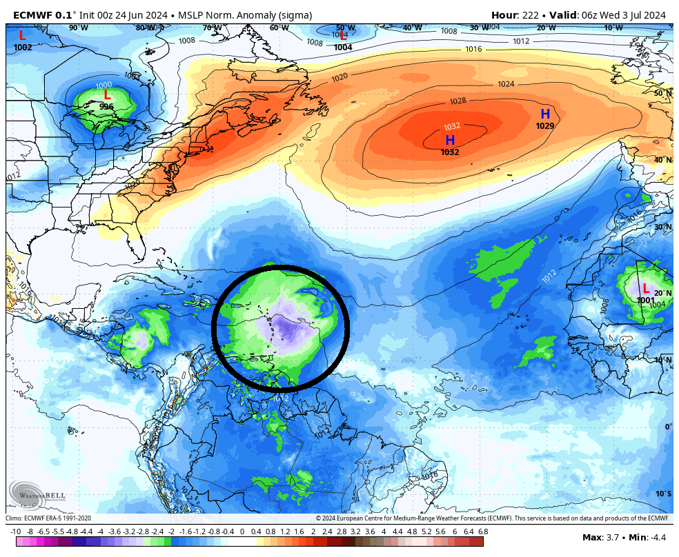
However, based on analysis of everything, I cannot totally rule this out, as in the ensemble diagrams, and 2 of the global models, higher pressures are forecast north of the MDR, which means MSLP anomalies to the south, should naturally lower, as the flow in the atmosphere goes from high pressure to lower pressure areas. Both the ECMWF and CMC do indicate areas of lowering pressure. The ECMWF EPS Cyclone Formation probability forecast does currently indicate low probs in the MDR in about 7 days. Anyway, be assured if I suspect anything, it will be mentioned, and I will try to provide the best information as possible.
CURRENT JMA ENSEMBLE MJO PHASE

ECMWF EPS CHI200 ANOMALIES

JMA WEEK 2

JMA AND ECMWF EPS WEEK 3 AND 4

JMA 3 MONTH MEAN

MJO PHASE CHART

MJO INDEX FORECAST ACCESS – S2 MODEL (NOTE THE MEMBERS TRYING TO COME OUT TO PHASE 2)

ECMWF MJO FORECAST (ALL PHASE SPACE DIAGRAMS RESEMBLED THIS)

ECMWF TROPICAL CYCLONE PROBABILITY FORECAST 
ENSEMBLE MEAN FORECAST DIAGRAMS


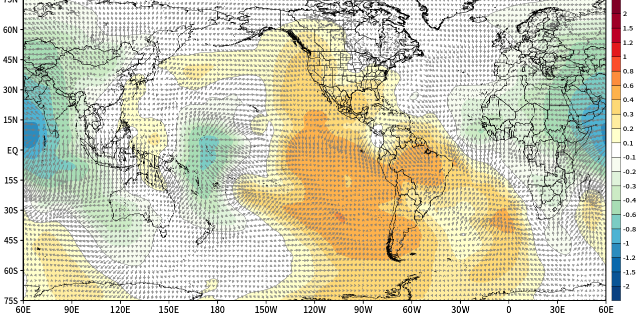
The following are forecast MSLP anomaly maps from the global models:
ECMWF
CMC GEM

The following is the SAL / dust forecast during the next 10 days.
NASA GEOS DUST FORECAST

I will continue to monitor the tropics daily for any significant changes during the next 5 – 7 days.
The following NWS Watch / Warning map will provide local NWS information for your area. Click the image, then once it refreshes, click on your area of interest to view any special weather statements, hazards or advisories for your area.
NWS WATCH / WARNING DISPLAY (LINKED…CLICK MAP, THEN YOUR AREA)

NWS DOPPLER RADAR LOOP (LINKED, CLICK RADAR MAP)

RAP RADAR (CLICK IMAGE THEN GO TO LOOP DURATION AND PICK LENGTH OF LOOP, THEN CLICK RADAR SITE)
CARIBBEAN RADAR (CLICK IMAGE TO ACCESS ANIMATION)

You may direct any questions by contacting me personally, ANYTIME, at: twalsh22000@yahoo.com
Have a blessed day!
T. F. “STORM” WALSH III
GMCS, USCG (ret)
METEOROLOGIST / HURRICANE SPECIALIST /SEVERE WEATHER SPECIALIST


