
ALL forecasts herein are the result of my analysis, (to which you will see me at times, insert excerpts from various agencies due to the nature of the importance of the information) and I am solely responsible for the content. As ALWAYS, follow the National Hurricane Center, National Weather Service, and your local Emergency Management officials for emergency decisions. In addition, this is strictly a FORECAST OFFICE. I CANNOT make decisions regarding travel plans, etc. My purpose, is to provide you the information based solely on information I analyze, and the accuracy of the information at hand of the time of analysis, so you may make informed decisions.
(T. F. “Storm” Walsh)
For those who have donated to my site, your help has been greatly appreciated. If you are not aware, donations to my site help pay for subscriptions to sites I use as well as software updates, which provide all the models and information used in my forecasts. To donate, please click the DONATE button to the right side of the page, or on the graphic of the dog. Any help you provide is immensely appreciated!
DONATIONS ACCEPTED AND APPRECIATED


If any of my subscribers here are on Facebook, and are in any of the weather groups I posted in, please let everyone know that Facebook suspended my old account. Since I may not be able to access Facebook anymore, you may follow me on twitter. The twitter button on the left of the page does not work. Please follow me here: https://twitter.com/Michael1227910
If you wish to become an email client and receive my forecasts by email, please send me an email at the email address at the bottom of the page…subject: EMAIL CLIENT.
I will reiterate, my forecasts are based on the available information at the time of analysis, and are only as accurate as the information analyzed and the solutions provided. Keep in mind, if a forecast doesn’t exactly pan out, remember, the atmosphere is fluid in motion. When models are being analyzed, that’s just one run, and I have to go with what is presented. After that, models don’t update again for another 4 – 6 hours, so, what happens between that time is unknown, and forecast conditions can change slightly, to greatly. This will have an effect on my actual forecast. Unless otherwise noted, satellite imagery is provided through Weathernerds.org
The following is my outlook forecast for the 2023 Atlantic Hurricane Season:
STORM W SEASONAL FORECAST
TOTAL NAMED STORMS: 14– 16
TOTAL HURRICANES : 5 – 7
MAJOR HURRICANES: 3 – 4
AVERAGE HURRICANE SEASON:
TOTAL NAMED STORMS: 14
TOTAL HURRICANES: 7
MAJOR HURRICANES: 3
SEASON TOTALS:
NAMED STORMS: 19
HURRICANES: 7
MAJOR HURRICANES: 3
The following are the storm names for the 2023 hurricane season. As each storm is named, they will be colored in red in order to keep track of the used names in the list:
Arlene Bret Cindy Don Emily Franklin Gert Harold Idalia Jose Katia
Lee Margot Nigel Ophelia Philippe Rina Sean Tammy Vince Whitney
Greetings everyone!
As a reminder, when forecasting tropical systems, if there are numerous systems to deal with, I always update on the systems that may present an impact or threat to either the U. S. or the Caribbean islands. Anything far out in the Atlantic or something that may re-curve, take a lower priority as there is more time to deal with them. Unless we have a system threatening any area, the forecast office will be closed on the weekends.
Satellite loop imagery indicates the low that was in the NW GOMEX 2 days ago, has moved to south of the MS/AL border. Satellite imagery shows a fairly defined LLC. Based on analysis of the models, this appears to split, forming a secondary low off of Florida’s east coast which is forecast to move NEWD. This low could still have a brief moment of causing minimal Tropical Storm force winds near the coastal area of the Florida Panhandle and northern big bend area. As the low redevelops off the east coast, the possibility of these same winds could occur along portions of the Florida east coast. This low is now forecast by the models to stay further offshore of the NE and New England areas, but could possibly enter the eastern portion of the Gulf of Maine as a Nor’easter.
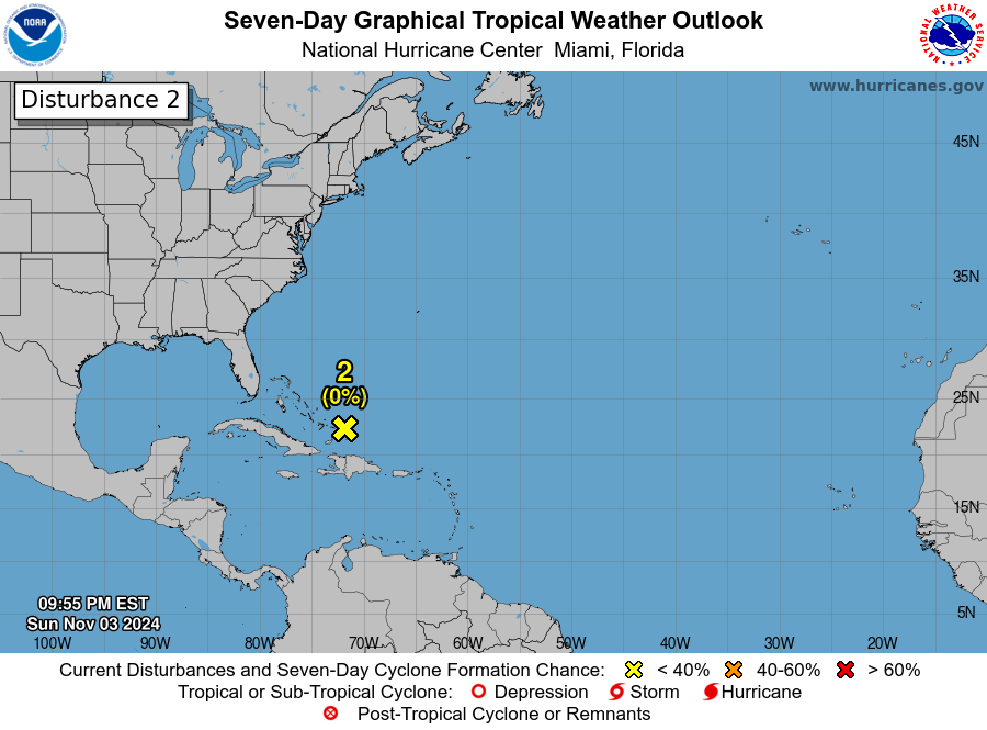
Analysis of the ECMWF and GFS global models still indicate a large low pressure system moving up out of the Caribbean over the next few days. Based on analysis of satellite loop imagery this morning, both models appear to be off on where the “center” is located. A center appears o be developing near 16.8N;81.4W, however another very small “swirl” seems to be located near 12.4N;80.2W. Based on this, the forecast would now indicate only marginal conditions for any development. While surface moisture based on analysis of Total Precipitable Water (TPW), and relative humidity values up to the mid level of the atmosphere remain very favorable up to about 66 – 72 hours in the forecast period. Although the ECMWF EPS CHI200 anomalies forecast indicates very strong divergence aloft over the next 5 days, wind shear is forecast to be marginal for development during the next 48 – 54 hours, increasing at the 66 – 72 hour period in the forecast, based on what the models are projecting, and if the location of the low is actually further NE than the model initialization. At around 72 hours, based on analysis of the 500 mb pattern, the system is forecast to merge with a mid level trough. The area is currently under about 25 – 30 kts of wind shear.
CIMSS WIND SHEAR MAP

The NHC has lowered the probability of cyclone formation to MEDIUM (50%). The ECMWF EPS cyclone probability forecast indicates a 80 – 85% probability of Tropical Depression development.
GOMEX AND CARIBBEAN SATELLITE LOOP IMAGERY


NHC 7 DAY GTWO

ECMWF EPS CYCLONE FORMATION PROBABILITY (TROPICAL DEPRESSION)

Based on the updated forecast conditions, I believe this has a much slimmer probability of becoming a depression, unless wind shear relaxes and becomes more of a radial pattern over the area, and I agree with the NHC reduction in cyclone formation probability.
I will continue to monitor the situation over the next 48 hours for any significant changes to forecast conditions.
ECMWF AND GFS MSLP ANOMALY FORECAST


SURFACE WIND FORECAST

PROJECTED 5 DAY RAINFALL TOTALS


The following map will allow to get information from your NWS office.
NWS WATCH / WARNING DISPLAY (LINKED…CLICK MAP, THEN YOUR AREA)

NWS DOPPLER RADAR LOOP (LINKED, CLICK RADAR MAP)

RAP RADAR (CLICK IMAGE THEN RADAR SITE…ONCE YOU CLICK THE SITE, GO TO LOOP DURATION TO CREATE A LOOP)
CARIBBEAN RADAR (CLICK IMAGE)

You may direct any questions by contacting me personally, ANYTIME, at: twalsh22000@yahoo.com
Have a blessed day!
T. F. “STORM” WALSH III
GMCS, USCG (ret)
METEOROLOGIST / HURRICANE SPECIALIST /SEVERE WEATHER SPECIALIST


